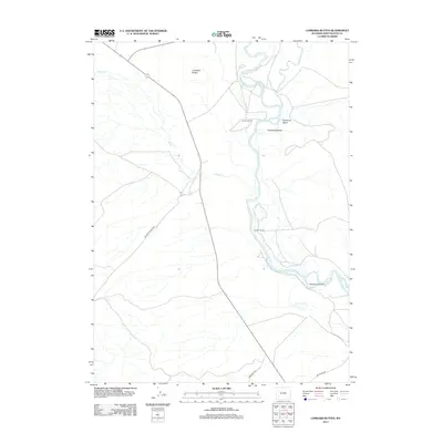
2012 Map of Lombard Buttes
USGS Topo · Published 2012About this map
The confluence of the Green River and the Big Sandy River anchors this landscape in Sweetwater County, where the desert terrain is shaped by historical migration and modern ranching. Traces of the mid-19th-century westward expansion are preserved in the paths of the Emigrant Trl and the route of Brigham Young 1847, crossing the open country west of the river. These tracks reflect the early overland journeys through the Wyoming interior before the arrival of established highways. Along the river banks, the Dunkle Ranch and Johnson Ranch represent the enduring agricultural presence in this arid region. The hydrology of the area is further defined by distinctive features such as Freezeout Island and Telephone Island, while the Lombard Buttes rise as prominent landmarks above the drainages of Eightmile Wash and Shute Cr.
Find a feature on this map
12 named features on this map. Tap any name to fly to it.
Don’t see what you’re looking for? This feature index may not catch every label — zoom into the map to look around manually.
Map Details
Editions of this 2012 Lombard Buttes Map
This is the sole edition of this map. No revisions or reprints were ever made.
Other maps of this area

1954 · Rock Springs
USGS Topo · 1:250,000

1958 · Rock Springs
USGS Topo · 1:250,000

1961 · Blue Point
USGS Topo · 1:24,000

1961 · Sevenmile Gulch
USGS Topo · 1:24,000

1961 · Stevens Flat
USGS Topo · 1:24,000

1962 · Rock Springs
USGS Topo · 1:250,000

1963 · Gasson Bridge
USGS Topo · 1:24,000

1963 · Big Island Bridge
USGS Topo · 1:24,000
1963 · Whiskey Buttes
USGS Topo · 1:24,000
1963 · Mc Cullen Bluff
USGS Topo · 1:24,000