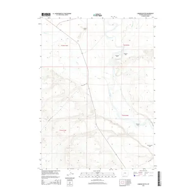
2015 Map of Lombard Buttes
USGS Topo · Published 2015About this map
The Brigham Young 1847 trail corridor cuts a historical diagonal across this Sweetwater County landscape, marking the westward passage through the high desert of Wyoming. The terrain is defined by the confluence of major waterways, where the Big Sandy River joins the meandering Green River. These river systems create a complex of riparian features, including named landmasses within the river channels such as Freezeout Island and Telephone Island. To the west, the Lombard Buttes provide significant topographical relief above the drainage basins of Shute Cr and various arid washes.
Find a feature on this map
14 named features on this map. Tap any name to fly to it.
Don’t see what you’re looking for? This feature index may not catch every label — zoom into the map to look around manually.
Map Details
Editions of this 2015 Lombard Buttes Map
This is the sole edition of this map. No revisions or reprints were ever made.
Other maps of this area

1954 · Rock Springs
USGS Topo · 1:250,000

1958 · Rock Springs
USGS Topo · 1:250,000

1961 · Blue Point
USGS Topo · 1:24,000

1961 · Sevenmile Gulch
USGS Topo · 1:24,000

1961 · Stevens Flat
USGS Topo · 1:24,000

1962 · Rock Springs
USGS Topo · 1:250,000

1963 · Gasson Bridge
USGS Topo · 1:24,000

1963 · Big Island Bridge
USGS Topo · 1:24,000
1963 · Whiskey Buttes
USGS Topo · 1:24,000
1963 · Mc Cullen Bluff
USGS Topo · 1:24,000