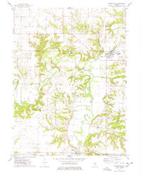
1974 Map of London Mills
USGS Topo · Published 1978About this map
The Spoon River carves a winding path through the borderlands of Knox and Fulton counties, defining a landscape shaped by both coal extraction and small-town commerce in the mid-1970s. The settlement of London Mills serves as a northern anchor, while Ellisville sits downstream to the south. Transportation and industry are central to this era, evidenced by the Chicago and North Western rail line and a prominent Strip Mine located in Chestnut township. Local genealogy is well-documented through several family and community burial grounds, including Pleasant Hill Cem, Heartley Cem, Flake Cem, and Landon Cem. The map also captures specialized rural features such as the Indian Ford Bridge and Camp Wilderness, reflecting a period when the river valley remained a vital corridor for both recreation and local industry.
Find a feature on this map
29 named features on this map. Tap any name to fly to it.
Don’t see what you’re looking for? This feature index may not catch every label — zoom into the map to look around manually.
Map Details
Editions of this 1974 London Mills Map
This is the sole edition of this map. No revisions or reprints were ever made.
Other maps of this area

1912 · Canton
USGS Topo · 1:62,500

1915 · Avon
USGS Topo · 1:62,500

1925 · Galesburg
USGS Topo · 1:62,500

1927 · Galesburg
USGS Topo · 1:62,500

1941 · Maquon
USGS Topo · 1:62,500

1943 · Maquon
USGS Topo · 1:62,500

1944 · Avon
USGS Topo · 1:62,500

1958 · Burlington
USGS Topo · 1:250,000

1961 · Burlington
USGS Topo · 1:250,000

1963 · Burlington
USGS Topo · 1:250,000