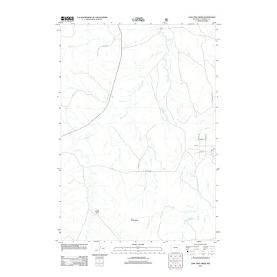
2012 Map of Lone Tree Creek
USGS Topo · Published 2012About this map
Little Powder River meanders through this portion of Campbell County, carving a drainage system that includes Cottonwood Cr and Lone Tree Cr. The landscape is defined by its ranching and resource extraction history, evidenced by the Ray Ranch in the north and the prominence of Oil Field Rd cutting across the central plains. To the south, the terrain becomes more distinct where Cow Creek Breaks and Hells Canyon Draw mark the transition toward the headwaters of N Fork Hay Cr. Water management is central to the area's utility, with both the Lone Tree Reservoir and Davis Reservoir positioned to support the local ecosystem and agricultural needs. The grid of roads in the east, including Bishop Rd and Soda Wells Rd, indicates more concentrated property divisions compared to the open rangeland to the west.
Find a feature on this map
21 named features on this map. Tap any name to fly to it.
Don’t see what you’re looking for? This feature index may not catch every label — zoom into the map to look around manually.
Map Details
Editions of this 2012 Lone Tree Creek Map
This is the sole edition of this map. No revisions or reprints were ever made.
Other maps of this area

1954 · Gillette
USGS Topo · 1:250,000

1955 · Gillette
USGS Topo · 1:250,000

1958 · Gillette
USGS Topo · 1:250,000

1962 · Gillette
USGS Topo · 1:250,000
1971 · Rozet NW
USGS Topo · 1:24,000

1971 · Green Hill
USGS Topo · 1:24,000
1971 · Moyer Springs
USGS Topo · 1:24,000
1972 · Oliver Draw
USGS Topo · 1:24,000
1972 · Gillette
USGS Topo · 1:100,000
1972 · Weston
USGS Topo · 1:24,000