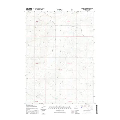
2015 Map of Lone Well Creek West
USGS Topo · Published 2015About this map
Buffalo Gap National Grassland dominates this section of Fall River County, preserving a landscape defined by its expansive drainage networks and open range. The area is dissected by numerous intermittent waterways, including the winding course of Lone Well Creek and the headwaters of Tepee Cr and Dry Cr. These natural features dictate the sparse human footprint, where section lines and rural routes such as Dry Creek Rd and Co Hwy 6f follow the contours of the high plains.
Find a feature on this map
16 named features on this map. Tap any name to fly to it.
Don’t see what you’re looking for? This feature index may not catch every label — zoom into the map to look around manually.
Map Details
Editions of this 2015 Lone Well Creek West Map
This is the sole edition of this map. No revisions or reprints were ever made.
Other maps of this area

1896 · Oelrichs
USGS Topo · 1:125,000

1900 · Oelrichs
USGS Topo · 1:125,000

1902 · Edgemont
USGS Topo · 1:125,000

1950 · Heppner
USGS Topo · 1:24,000

1950 · Cascade Springs
USGS Topo · 1:24,000

1950 · Hot Springs SE
USGS Topo · 1:24,000

1950 · Angostura Reservoir
USGS Topo · 1:24,000

1955 · Hot Springs
USGS Topo · 1:250,000
1982 · Black Banks Creek East
USGS Topo · 1:24,000
1982 · Black Banks Creek West
USGS Topo · 1:25,000