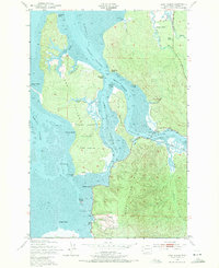
1949 Map of Long Island
USGS Topo · Published 1971About this map
Long Island dominates this coastal survey, serving as the central landmass within the tidal waters of Willapa Bay and Willapa Harbor. The map reveals a landscape defined by an intricate network of waterways, including the Stanley Channel and Nahcotta Channel, which surround the island's many points and sloughs. To the east, the timbered slopes of Bear River Ridge rise above the drainage of the Naselle River and Ellsworth Creek.
Find a feature on this map
38 named features on this map. Tap any name to fly to it.
Don’t see what you’re looking for? This feature index may not catch every label — zoom into the map to look around manually.
Map Details
Editions of this 1949 Long Island Map
3 editions found

Other maps of this area

1938 · Cape Disappointment
USGS Topo · 1:62,500

1938 · Cape Shoalwater
USGS Topo · 1:62,500

1938 · Fort Columbia
USGS Topo · 1:62,500

1938 · South Bend
USGS Topo · 1:62,500

1940 · South Bend
USGS Topo · 1:62,500

1943 · Fort Columbia
USGS Topo · 1:62,500

1943 · Copalis Beach
USGS Topo · 1:250,000

1949 · Chinook
USGS Topo · 1:24,000

1949 · Oman Ranch
USGS Topo · 1:24,000

1949 · Knappton
USGS Topo · 1:24,000