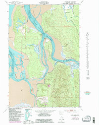
1949 Map of Long Island
USGS Topo · Published 1985About this map
Willapa National Wildlife Refuge dominates the landscape of this mid-century hydrographic and topographic study, where the complex tides of Willapa Bay meet the forested uplands of Pacific County. The map provides a detailed view of the massive Long Island, separated from the mainland by the Stanley Channel and Long Island Slough. This area is defined by its intricate network of sloughs and tidal channels, including Lewis Slough and Kuffee Slough, which weave through the marshy lowlands.
Find a feature on this map
33 named features on this map. Tap any name to fly to it.
Don’t see what you’re looking for? This feature index may not catch every label — zoom into the map to look around manually.
Map Details
Editions of this 1949 Long Island Map
3 editions found

Other maps of this area

1938 · Cape Disappointment
USGS Topo · 1:62,500

1938 · Cape Shoalwater
USGS Topo · 1:62,500

1938 · Fort Columbia
USGS Topo · 1:62,500

1938 · South Bend
USGS Topo · 1:62,500

1940 · South Bend
USGS Topo · 1:62,500

1943 · Fort Columbia
USGS Topo · 1:62,500

1943 · Copalis Beach
USGS Topo · 1:250,000

1949 · Chinook
USGS Topo · 1:24,000

1949 · Oman Ranch
USGS Topo · 1:24,000

1949 · Knappton
USGS Topo · 1:24,000