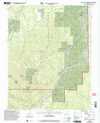
2002 Map of Long Valley Junction
USGS Topo · Published 2005About this map
Long Valley Junction serves as the primary landmark in this high-elevation landscape where the East Fork Virgin River begins its course through the valley. Situated on the Markagunt Plateau, the terrain is defined by a complex network of canyons including Dairy Canyon, Stout Canyon, and Johnson Canyon, all leading away from the prominent Pink Cliffs. This 2002 revision reflects the management boundaries of the Dixie National Forest and the Cedar City Ranger District, illustrating how public lands are partitioned in this part of Kane County. Water sources are critical features of this environment, evidenced by named springs and small catchments like Mc Donald Lake, Le Vanger Lakes, and Harris Spring. The presence of a Landing Strip and Roadside Park near the junction highlights the area's role as a transit point for those navigating the high country between major regional landmarks.
Find a feature on this map
45 named features on this map. Tap any name to fly to it.
Don’t see what you’re looking for? This feature index may not catch every label — zoom into the map to look around manually.
Map Details
Editions of this 2002 Long Valley Junction Map
This is the sole edition of this map. No revisions or reprints were ever made.
Other maps of this area

1886 · Kanab
USGS Topo · 1:250,000

1953 · Cedar City
USGS Topo · 1:250,000

1958 · Cedar City
USGS Topo · 1:250,000

1958 · Orderville
USGS Topo · 1:62,500

1958 · Panguitch Lake
USGS Topo · 1:62,500

1962 · Cedar City
USGS Topo · 1:250,000

1966 · Alton
USGS Topo · 1:24,000

1966 · Bald Knoll
USGS Topo · 1:24,000

1966 · George Mtn
USGS Topo · 1:24,000

1980 · Panguitch
USGS Topo · 1:100,000