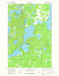
1971 Map of Longville
USGS Topo · Published 1978About this map
Chippewa National Forest surrounds the interconnected waters of central Cass County, where the Boy River links a dense chain of glacial lakes. The settlement of Longville serves as the local hub, featuring the Longville Municipal Airport and Sewage Disp Ponds as evidence of mid-century infrastructure growth. To the south, the landscape is defined by the large basins of Little Boy Lake and Wabedo Lake, separated by narrow channels and public access points. This 1970s survey captures a transition in land use, showing established recreation sites like Camp Olson alongside the Wabedo Cem and a Townhall. Notable landmarks for navigation and fire watch include the Longville Lookout Tower and a dedicated Winter Trail cutting through the eastern woods. Numerous Gravel Pits scattered near the shoreline suggest the active maintenance of local roads and development during this era.
Find a feature on this map
49 named features on this map. Tap any name to fly to it.
Don’t see what you’re looking for? This feature index may not catch every label — zoom into the map to look around manually.
Map Details
Editions of this 1971 Longville Map
2 editions found
Other maps of this area

1953 · Brainerd
USGS Topo · 1:250,000

1954 · Bemidji
USGS Topo · 1:250,000

1957 · Brainerd
USGS Topo · 1:250,000

1957 · Bemidji
USGS Topo · 1:250,000

1958 · Bemidji
USGS Topo · 1:250,000

1958 · Brainerd
USGS Topo · 1:250,000

1965 · Brainerd
USGS Topo · 1:250,000

1970 · Laura Lake
USGS Topo · 1:24,000
1970 · Mitchell Lake
USGS Topo · 1:24,000

1970 · Woman Lake
USGS Topo · 1:24,000