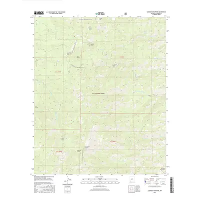
2017 Map of Lookout Mountain
USGS Topo · Published 2017About this map
The Black Range dominates this portion of the Gila National Forest, where the topography is defined by high-altitude ridges and deep drainages. The Continental Divide National Scenic Trail winds along the crest, crossing the Continental Divide as it traverses the high ground near Lookout Mountain. This rugged terrain is punctuated by numerous seasonal water sources and landmarks that speak to the area's grazing and early exploration history, such as Lookout Tank and Sawmill Cabin Spring. The complex network of canyons, including the steep-walled Hell Canyon, Fisherman Canyon, and Doubtful Canyon, illustrates the extreme vertical relief of the southwestern New Mexico landscape. Named features like James Brothers Spring and Moccasin John Canyon provide specific points of interest for genealogists and local historians tracing the presence of early settlers and ranchers in this part of Sierra County.
Find a feature on this map
38 named features on this map. Tap any name to fly to it.
Don’t see what you’re looking for? This feature index may not catch every label — zoom into the map to look around manually.
Map Details
Editions of this 2017 Lookout Mountain Map
This is the sole edition of this map. No revisions or reprints were ever made.
Other maps of this area

1949 · Lookout Mountain
USGS Topo · 1:62,500

1954 · Tularosa
USGS Topo · 1:250,000

1958 · Tularosa
USGS Topo · 1:250,000

1963 · Bonner Canyon
USGS Topo · 1:24,000

1963 · Reeds Peak
USGS Topo · 1:24,000

1963 · Sugarloaf Peak
USGS Topo · 1:24,000

1965 · Winston
USGS Topo · 1:24,000

1965 · Iron Mountain
USGS Topo · 1:24,000

1979 · Truth or Consequences
USGS Topo · 1:100,000
1981 · Taylor Peak
USGS Topo · 1:24,000