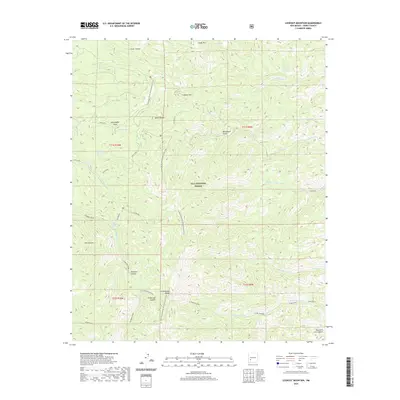
2020 Map of Lookout Mountain
USGS Topo · Published 2020About this map
The Continental Divide National Scenic Trail winds through the high-elevation landscape of the Gila National Forest, crossing a topography defined by steep canyons and seasonal water sources. Centered on the Black Range, this 2020 survey documents a network of vital springs such as Spruce Spring, Wild Cow Spring, and Ben Spring that historically sustained movement through this arid environment. The naming conventions, such as Seventyfour Draw and James Brothers Spring, suggest a legacy of early ranching and frontier settlement. Farther south, the terrain breaks into complex drainage systems like Fisherman Canyon and Doubtful Canyon, which feed into larger watercourses including Diamond Creek. The map provides a clear look at the intersection of natural hydrology and historic trails used by travelers navigating the Continental Divide.
Find a feature on this map
44 named features on this map. Tap any name to fly to it.
Don’t see what you’re looking for? This feature index may not catch every label — zoom into the map to look around manually.
Map Details
Editions of this 2020 Lookout Mountain Map
This is the sole edition of this map. No revisions or reprints were ever made.
Other maps of this area

1949 · Lookout Mountain
USGS Topo · 1:62,500

1954 · Tularosa
USGS Topo · 1:250,000

1958 · Tularosa
USGS Topo · 1:250,000

1963 · Bonner Canyon
USGS Topo · 1:24,000

1963 · Reeds Peak
USGS Topo · 1:24,000

1963 · Sugarloaf Peak
USGS Topo · 1:24,000

1965 · Winston
USGS Topo · 1:24,000

1965 · Iron Mountain
USGS Topo · 1:24,000

1979 · Truth or Consequences
USGS Topo · 1:100,000
1981 · Taylor Peak
USGS Topo · 1:24,000