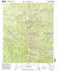
1999 Map of Lookout Mountain
USGS Topo · Published 2002About this map
The Continental Divide winds through this high-altitude landscape in Sierra County, marking a fundamental geographic boundary within the Gila National Forest. This 1999 revision captures a remote wilderness area defined by complex drainages and early resource extraction, centered around the Lookout Mountain summit. The presence of the Lookout Mine and various unnamed mines along the slopes of Blackhawk Gulch and Chloride Creek point to the region's historical mineral interest.
Find a feature on this map
39 named features on this map. Tap any name to fly to it.
Don’t see what you’re looking for? This feature index may not catch every label — zoom into the map to look around manually.
Map Details
Editions of this 1999 Lookout Mountain Map
This is the sole edition of this map. No revisions or reprints were ever made.
Other maps of this area

1949 · Lookout Mountain
USGS Topo · 1:62,500

1954 · Tularosa
USGS Topo · 1:250,000

1958 · Tularosa
USGS Topo · 1:250,000

1963 · Bonner Canyon
USGS Topo · 1:24,000

1963 · Reeds Peak
USGS Topo · 1:24,000

1963 · Sugarloaf Peak
USGS Topo · 1:24,000

1965 · Winston
USGS Topo · 1:24,000

1965 · Iron Mountain
USGS Topo · 1:24,000

1979 · Truth or Consequences
USGS Topo · 1:100,000
1981 · Taylor Peak
USGS Topo · 1:24,000