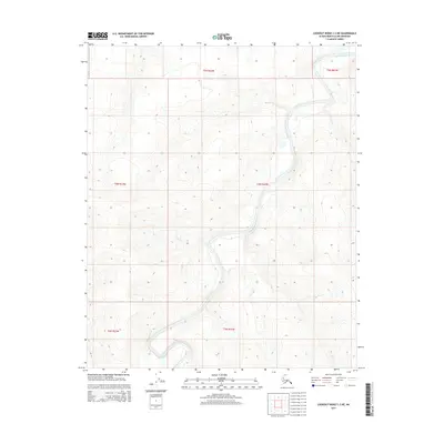
2015 Map of Lookout Ridge C-3 NE
USGS Topo · Published 2015About this map
Meade River dominates this Arctic landscape, winding through the remote terrain of the North Slope. This 2015 survey reveals the complex hydrologic character of the region, where the river's meandering path creates a distinct pattern of drainage across the northern plains. The topographic detail highlights the subtle elevation changes within t5n r22w, t4n r22w, and surrounding townships, illustrating how the water defines the geography of this uninhabited wilderness. The absence of roads or settlements underscores the isolation of this corner of the Alaska North Slope Borough, providing an undisturbed view of the natural drainage systems as they existed in the early 21st century.
Find a feature on this map
7 named features on this map. Tap any name to fly to it.
Don’t see what you’re looking for? This feature index may not catch every label — zoom into the map to look around manually.
Map Details
Editions of this 2015 Lookout Ridge C-3 NE Map
This is the sole edition of this map. No revisions or reprints were ever made.
Other maps of this area

1951 · Lookout Ridge
USGS Topo · 1:250,000

1956 · Lookout Ridge
USGS Topo · 1:250,000
1984 · Lookout Ridge D-2
USGS Topo · 1:63,360

1984 · Lookout Ridge D-3
USGS Topo · 1:63,360
1985 · Lookout Ridge C-3
USGS Topo · 1:63,360
1985 · Lookout Ridge C-2
USGS Topo · 1:63,360
2013 · Lookout Ridge D-3 SE
USGS Topo · 1:25,000
2013 · Lookout Ridge D-3 SW
USGS Topo · 1:25,000
2015 · Lookout Ridge C-3 NW
USGS Topo · 1:25,000
2015 · Lookout Ridge C-2 SW
USGS Topo · 1:25,000