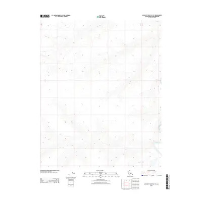
2013 Map of Lookout Ridge D-3 SE
USGS Topo · Published 2013About this map
Meade River defines the eastern edge of this terrain in the Alaskan North Slope, cutting a sinuous path through the tundra of Lookout Ridge. This 2013 survey illustrates the dramatic elevation changes characteristic of the Arctic foothills, where subtle ridges and deep drainage basins dominate the landscape. The topographic data reveals the intricate hydrological patterns of the region, showcasing how the river meanders through the township boundaries of T 6 N and T 5 N. This map serves as a primary record of the remote wilderness within the North Slope Borough, capturing the land before any modern infrastructure altered its natural state.
Find a feature on this map
39 named features on this map. Tap any name to fly to it.
Don’t see what you’re looking for? This feature index may not catch every label — zoom into the map to look around manually.
Map Details
Editions of this 2013 Lookout Ridge D-3 SE Map
This is the sole edition of this map. No revisions or reprints were ever made.
Other maps of this area

1951 · Lookout Ridge
USGS Topo · 1:250,000

1956 · Lookout Ridge
USGS Topo · 1:250,000
1984 · Lookout Ridge D-2
USGS Topo · 1:63,360

1984 · Lookout Ridge D-3
USGS Topo · 1:63,360
1985 · Lookout Ridge C-3
USGS Topo · 1:63,360
1985 · Lookout Ridge C-2
USGS Topo · 1:63,360
2013 · Lookout Ridge D-3 NW
USGS Topo · 1:25,000
2013 · Lookout Ridge D-3 NE
USGS Topo · 1:25,000
2013 · Lookout Ridge D-3 SW
USGS Topo · 1:25,000
2015 · Lookout Ridge C-3 NW
USGS Topo · 1:25,000