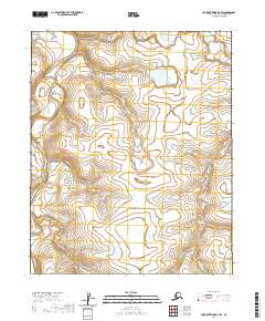
2020 Map of Lookout Ridge D-2 SW
USGS Topo · Published 2020About this map
The Meade River winds through the far northern reaches of the North Slope in this 2020 topographic survey. This remote Arctic landscape is defined by the braided path of the river as it flows northward through the National Petroleum Reserve. In the eastern portion of the map, the Usuktuk River carves a similar course, illustrating the intricate drainage patterns of the tundra. The vast, treeless terrain is segmented by township and range lines, such as t6n r21w and t5n r20w, marking the administrative divisions of this sparsely populated wilderness. The map provides a look at the hydrography of the region before significant changes in the permafrost or shoreline might alter these ancient waterways.
Find a feature on this map
6 named features on this map. Tap any name to fly to it.
Don’t see what you’re looking for? This feature index may not catch every label — zoom into the map to look around manually.
Map Details
Editions of this 2020 Lookout Ridge D-2 SW Map
This is the sole edition of this map. No revisions or reprints were ever made.
Other maps of this area

1951 · Lookout Ridge
USGS Topo · 1:250,000

1956 · Lookout Ridge
USGS Topo · 1:250,000
1984 · Lookout Ridge D-2
USGS Topo · 1:63,360

1984 · Lookout Ridge D-3
USGS Topo · 1:63,360
1985 · Lookout Ridge C-3
USGS Topo · 1:63,360
1985 · Lookout Ridge C-2
USGS Topo · 1:63,360
2013 · Lookout Ridge D-3 NE
USGS Topo · 1:25,000
2013 · Lookout Ridge D-3 SE
USGS Topo · 1:25,000
2015 · Lookout Ridge D-2 SE
USGS Topo · 1:25,000
2015 · Lookout Ridge C-2 NE
USGS Topo · 1:25,000