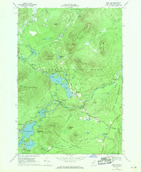
1968 Map of Loon Lake
USGS Topo · Published 1970About this map
Loon Lake and the surrounding peaks of the Adirondack State Park dominate this 1960s topographic landscape in Franklin County. The map documents a transition from industrial exploitation to recreational preservation within the State Forest Preserve. To the south, an Old Railroad Grade and Old Grade Railroad corridor trace a path through the wetlands near Lake Kushaqua and Mud Pond, marking the legacy of regional logging or transport lines that once bypassed the Loon Lake Mountains.
Find a feature on this map
65 named features on this map. Tap any name to fly to it.
Don’t see what you’re looking for? This feature index may not catch every label — zoom into the map to look around manually.
Map Details
Editions of this 1968 Loon Lake Map
2 editions found
Other maps of this area

1896 · Lake Placid
USGS Topo · 1:62,500

1898 · Lake Placid
USGS Topo · 1:62,500

1902 · Saranac
USGS Topo · 1:62,500

1904 · Saranac
USGS Topo · 1:62,500

1906 · Loon Lake
USGS Topo · 1:62,500

1908 · Loon Lake
USGS Topo · 1:62,500

1911 · Lyon Mountain
USGS Topo · 1:62,500

1913 · Lyon Mountain
USGS Topo · 1:62,500

1931 · Lyon Mountain
USGS Topo · 1:62,500

1948 · Ogdensburg
USGS Topo · 1:250,000