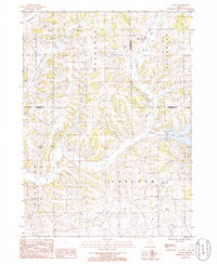
1985 Map of Loran
USGS Topo · Published 1986About this map
Loran serves as the primary point of settlement on this mid-1980s landscape, situated where the terrain transitions between the flat-topped ridges and the carved valleys of northwest Illinois. The map documents a predominantly agricultural area characterized by its natural watercourses, notably the winding path of Muddy Plum. These stream networks once dictated the placement of pioneer-era homesteads and early road systems, many of which are preserved here in their late-twentieth-century configurations. Researchers can trace the drainage patterns and township divisions that have shaped the rural character of this region for generations.
Find a feature on this map
2 named features on this map. Tap any name to fly to it.
Don’t see what you’re looking for? This feature index may not catch every label — zoom into the map to look around manually.
Map Details
Editions of this 1985 Loran Map
This is the sole edition of this map. No revisions or reprints were ever made.
Other maps of this area

1892 · Savanna
USGS Topo · 1:62,500

1911 · Elizabeth
USGS Topo · 1:62,500

1936 · Elizabeth
USGS Topo · 1:62,500

1937 · Lena
USGS Topo · 1:48,000

1942 · Mt Carroll
USGS Topo · 1:62,500

1942 · Lena
USGS Topo · 1:62,500

1943 · Lena
USGS Topo · 1:62,500

1944 · Mt Carroll
USGS Topo · 1:62,500

1952 · Savanna
USGS Topo · 1:62,500

1954 · Rockford
USGS Topo · 1:250,000
Featured Places
- Loran, IL
- Berreman Township, IL
- Pleasant Valley Township, IL
- Stephenson County, IL
- Jo Daviess County, IL