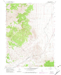
1967 Map of Loray
USGS Topo · Published 1983About this map
Murdock Mountain and the Toano Range dominate this high-desert landscape in eastern Elko County. The map documents a critical transportation corridor where the Southern Pacific railroad cuts through the Tecoma Valley, flanked by the steep drainage of Loray Wash. The scarcity of water in this arid environment is evident by the reliance on specific points like Murdock Springs, Boyd Spring, and Cobre Well to support livestock and travelers. Industrial activity is visible through several Prospects and a Borrow Pit near the southern rail line. While largely open range, the presence of a Corral and numerous Jeep Trails and Pack Trails indicates an active era of ranching and exploration. A solitary Radio Tower stands as a modern landmark against the traditional landscape of Loray Draw and Immigrant Cr.
Find a feature on this map
20 named features on this map. Tap any name to fly to it.
Don’t see what you’re looking for? This feature index may not catch every label — zoom into the map to look around manually.
Map Details
Editions of this 1967 Loray Map
2 editions found
Other maps of this area

1955 · Wells
USGS Topo · 1:250,000

1958 · Wells
USGS Topo · 1:250,000

1961 · Wells
USGS Topo · 1:250,000

1967 · Valley Pass
USGS Topo · 1:24,000

1967 · Loray
USGS Topo · 1:24,000

1967 · Montello Canyon
USGS Topo · 1:24,000

1967 · Montello
USGS Topo · 1:24,000
1967 · Pilot Peak NW
USGS Topo · 1:24,000
1967 · Pilot Peak SW
USGS Topo · 1:24,000

1967 · Ninemile Mtn SW
USGS Topo · 1:24,000