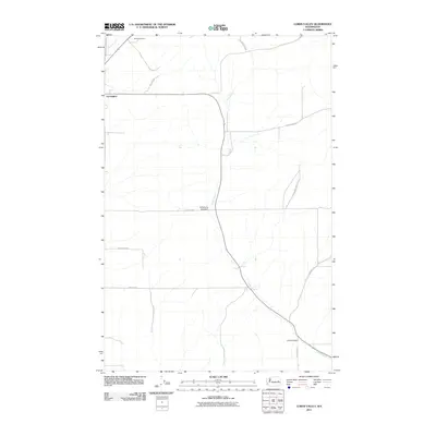
2011 Map of Lords Valley
USGS Topo · Published 2011About this map
Lords Valley defines the landscape of this Lincoln County survey, where the drainages of Lords Creek and Coal Creek cut through the agricultural plains of eastern Washington. The map centers on the rural infrastructure that supports this farming region, notably the Armstrong Lake Dam and several long-established family-named transit routes such as Gilliland Ranch Rd N and Camenzind Rd. The small settlement of Harrington appears at the northwestern corner of the quadrangle, serving as a vital node for the surrounding wheat country. Local aviation history is represented by Hanes Airport, situated north of the primary road network. This topographic study documents the persistent rural character of the Big Bend country, where the intersection of Mohler Rd E and Platter Rd N marks the heart of the valley's drainage system.
Find a feature on this map
18 named features on this map. Tap any name to fly to it.
Don’t see what you’re looking for? This feature index may not catch every label — zoom into the map to look around manually.
Map Details
Editions of this 2011 Lords Valley Map
This is the sole edition of this map. No revisions or reprints were ever made.
Other maps of this area

1953 · Ritzville
USGS Topo · 1:250,000

1959 · Ritzville
USGS Topo · 1:250,000

1965 · Ritzville
USGS Topo · 1:250,000

1969 · Bluestem
USGS Topo · 1:24,000

1969 · Harrington
USGS Topo · 1:24,000

1969 · Sprague Lake
USGS Topo · 1:24,000

1969 · Lords Valley
USGS Topo · 1:24,000

1969 · Omans
USGS Topo · 1:24,000
1969 · Sprague Lake SW
USGS Topo · 1:24,000
1969 · Rocklyn SE
USGS Topo · 1:24,000