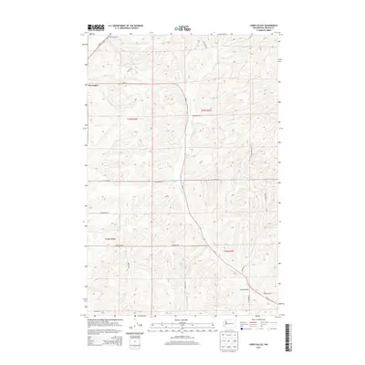
2013 Map of Lords Valley
USGS Topo · Published 2013About this map
Harrington sits at the edge of this Lincoln County landscape, where the basalt-carved terrain of the Channeled Scablands meets the agricultural plateaus of eastern Washington. The land is defined by the winding course of Lords Cr, which cuts through the southern reaches of the quadrangle toward the settlement of Lords Valley. This 2013 survey reveals a rural infrastructure built around ranching and transit, with long-established property lines reflected in the township and range boundaries of t23n r36e and t23n r37e. The map documents a network of family-named roads such as Burke Rd N, Platter Rd N, and Jenkins Rd N, alongside local landmarks like Armstrong Lake and Hanes Airport. High ridges and bluffs, including Gilliland Ranch Blf N, offer clear evidence of the region’s glacial flood history, providing a detailed record for those studying the intersection of geology and Pacific Northwest homesteading.
Find a feature on this map
24 named features on this map. Tap any name to fly to it.
Don’t see what you’re looking for? This feature index may not catch every label — zoom into the map to look around manually.
Map Details
Editions of this 2013 Lords Valley Map
This is the sole edition of this map. No revisions or reprints were ever made.
Other maps of this area

1953 · Ritzville
USGS Topo · 1:250,000

1959 · Ritzville
USGS Topo · 1:250,000

1965 · Ritzville
USGS Topo · 1:250,000

1969 · Bluestem
USGS Topo · 1:24,000

1969 · Harrington
USGS Topo · 1:24,000

1969 · Sprague Lake
USGS Topo · 1:24,000

1969 · Lords Valley
USGS Topo · 1:24,000

1969 · Omans
USGS Topo · 1:24,000
1969 · Sprague Lake SW
USGS Topo · 1:24,000
1969 · Rocklyn SE
USGS Topo · 1:24,000