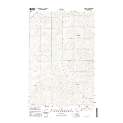
2017 Map of Lords Valley
USGS Topo · Published 2017About this map
Lords Valley and its eponymous watercourse, Lords Cr, dominate this Washington landscape in Lincoln County. The area is defined by a systematic grid of section lines and rural roadways, many bearing the names of local families and early settlers. Notable transportation and aviation markers include Hanes Airport in the northwest and a network of named routes such as Harrington Tokio Rd and Star Barn Rd N. The topography is characterized by the presence of Armstrong Lake, providing a rare water feature amidst the complex drainages that define this portion of the Columbia Plateau. Large-scale land management is evident through the clear delineation of townships, including t23n r36e and t23n r37e, reflecting the region's agricultural and surveying history.
Find a feature on this map
24 named features on this map. Tap any name to fly to it.
Don’t see what you’re looking for? This feature index may not catch every label — zoom into the map to look around manually.
Map Details
Editions of this 2017 Lords Valley Map
This is the sole edition of this map. No revisions or reprints were ever made.
Other maps of this area

1953 · Ritzville
USGS Topo · 1:250,000

1959 · Ritzville
USGS Topo · 1:250,000

1965 · Ritzville
USGS Topo · 1:250,000

1969 · Bluestem
USGS Topo · 1:24,000

1969 · Harrington
USGS Topo · 1:24,000

1969 · Sprague Lake
USGS Topo · 1:24,000

1969 · Lords Valley
USGS Topo · 1:24,000

1969 · Omans
USGS Topo · 1:24,000
1969 · Sprague Lake SW
USGS Topo · 1:24,000
1969 · Rocklyn SE
USGS Topo · 1:24,000