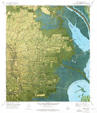
1973 Map of Loreauville
USGS Topo · Published 1976About this map
The low-lying cane and rice fields of Iberia Parish define this orthophotomap, showing the landscape as it transitioned between traditional agriculture and modern industrial use in the early 1970s. The settlement of Loreauville sits along a bend in the Bayou du Portage, flanked by smaller communities like Oubre and Bronson. The western edge is dominated by the Missouri Pacific railroad line, while the eastern half of the map gives way to the marshy expanse of the Atchafalaya Basin Floodway. Traces of local history are visible in the many rural religious sites, including Mt Zion Ch and St John Ch, alongside signs of the region's energy economy such as the Oil Field near Eagle Point and scattered Gas Well sites. The intricate network of waterways like Dauterive Lake and Lake Fausse Pointe highlights the delicate balance between the land and the surrounding wetlands.
Find a feature on this map
40 named features on this map. Tap any name to fly to it.
Don’t see what you’re looking for? This feature index may not catch every label — zoom into the map to look around manually.
Map Details
Editions of this 1973 Loreauville Map
This is the sole edition of this map. No revisions or reprints were ever made.
Other maps of this area

1937 · Jeanerette
USGS Topo · 1:62,500

1937 · Derouen
USGS Topo · 1:62,500

1939 · St. Martinsville
USGS Topo · 1:62,500

1941 · Loreauville
USGS Topo · 1:62,500

1945 · New Orleans
USGS Topo · 1:250,000

1954 · Loreauville
USGS Topo · 1:62,500

1954 · Jeanerette
USGS Topo · 1:62,500

1954 · Baton Rouge
USGS Topo · 1:250,000

1956 · Baton Rouge
USGS Topo · 1:250,000

1957 · St. Martinville
USGS Topo · 1:62,500