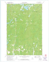
1971 Map of Loretta
USGS Topo · Published 1973About this map
Loretta and Draper serve as the primary nodes of activity in this northern Wisconsin landscape, situated along a corridor defined by the Brunet River and the expansive Chequamegon National Forest. The 1971 field check reveals a region heavily defined by its waterways and timber resources, where the East Fork Chippewa River and the Flambeau River mark the boundaries of public forest lands. This survey documents the seasonal and recreational character of the area, noting several gravel pits and the Brunet Lookout Tower atop the rising terrain. Beyond the clustered residences of the small settlements, the map traces a Snowmobile Trail and names numerous water bodies such as Bear Lake, Loretta Lake, and Blaisdell Lake, reflecting the region's transition into a destination for outdoor enthusiasts in the latter half of the twentieth century.
Find a feature on this map
25 named features on this map. Tap any name to fly to it.
Don’t see what you’re looking for? This feature index may not catch every label — zoom into the map to look around manually.
Map Details
Editions of this 1971 Loretta Map
2 editions found
Other maps of this area

1941 · Kennedy
USGS Topo · 1:48,000

1942 · Glidden
USGS Topo · 1:48,000

1942 · Clam Lake
USGS Topo · 1:48,000

1944 · Draper
USGS Topo · 1:48,000

1945 · Kennedy
USGS Topo · 1:48,000

1945 · Clam Lake
USGS Topo · 1:48,000

1945 · Glidden
USGS Topo · 1:48,000

1947 · Draper
USGS Topo · 1:48,000

1953 · Ashland
USGS Topo · 1:250,000

1953 · Rice Lake
USGS Topo · 1:250,000