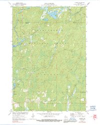
1971 Map of Loretta
USGS Topo · Published 1991About this map
Draper and Loretta serve as the primary human settlements in this northern Wisconsin landscape, appearing at a time when the timber and recreation economy defined the region. Located near the Sawyer Co and Ashland Co border, the area is dominated by the dense woodlands of the Chequamegon National Forest. The complex drainage patterns of the Chippewa River and the Flambeau River are visible, with smaller tributaries like Flyblow Creek and Swanson Creek feeding into numerous glacial lakes. The presence of the Brunet Lookout Tower highlights the era's fire management infrastructure within the forest, while Deer Haven Camp and a prominent Snowmobile Trail indicate the established recreational use of the land. Mapping also captures the irregular shoreline of Bear Lake and the marshy edges of Loretta Lake, providing a clear view of the aquatic geography before modern development or environmental shifts altered the Northwoods interior.
Find a feature on this map
23 named features on this map. Tap any name to fly to it.
Don’t see what you’re looking for? This feature index may not catch every label — zoom into the map to look around manually.
Map Details
Editions of this 1971 Loretta Map
2 editions found
Other maps of this area

1941 · Kennedy
USGS Topo · 1:48,000

1942 · Glidden
USGS Topo · 1:48,000

1942 · Clam Lake
USGS Topo · 1:48,000

1944 · Draper
USGS Topo · 1:48,000

1945 · Kennedy
USGS Topo · 1:48,000

1945 · Clam Lake
USGS Topo · 1:48,000

1945 · Glidden
USGS Topo · 1:48,000

1947 · Draper
USGS Topo · 1:48,000

1953 · Ashland
USGS Topo · 1:250,000

1953 · Rice Lake
USGS Topo · 1:250,000