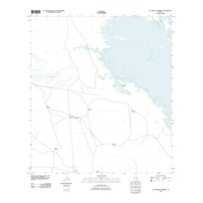
2010 Map of Los Amigos Windmill
USGS Topo · Published 2010About this map
Laguna Madre dominates the eastern landscape of this coastal Texas quadrangle, where the shallow waters and intricate shorelines of Rincon de la Soledad and Mesquite Rincon meet the South Texas ranching country. The map illustrates a sparse, working landscape defined by essential water infrastructure. A network of unimproved roads connects numerous named windmill sites, including Los Amigos Windmill, Soledad Windmill, and Santa Cruz Windmill, which serve as primary landmarks in this low-lying environment. The presence of features like Cayo Soledad alongside these distributed water points reflects the intersection of coastal geography and the pastoral demands of Kenedy County. The reliance on these specific named landmarks suggests a region where terrain and utility are deeply intertwined, providing a clear view of the area's rural character at the start of the 21st century.
Find a feature on this map
24 named features on this map. Tap any name to fly to it.
Don’t see what you’re looking for? This feature index may not catch every label — zoom into the map to look around manually.
Map Details
Editions of this 2010 Los Amigos Windmill Map
This is the sole edition of this map. No revisions or reprints were ever made.
Other maps of this area

1921 · Tarida Ranch
USGS Topo · 1:62,500

1923 · Lopena Island
USGS Topo · 1:62,500

1923 · Saltillo Ranch
USGS Topo · 1:62,500

1951 · Potrero Lopeno NW
USGS Topo · 1:24,000

1952 · South of Potrero Lopeno NW
USGS Topo · 1:24,000

1952 · Potrero Lopeno SW
USGS Topo · 1:24,000

1952 · Potrero Lopeno
USGS Topo · 1:62,500

1952 · South of Potrero Lopeno
USGS Topo · 1:62,500

1953 · Brownsville
USGS Topo · 1:250,000
1956 · San Pedro Ranch
USGS Topo · 1:24,000