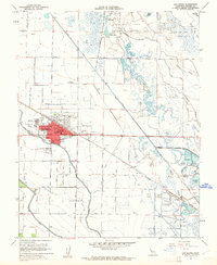
1960 Map of Los Banos
USGS Topo · Published 1961About this map
Los Banos serves as the hub of this Central Valley landscape, centered at the intersection of the Southern Pacific railroad and major thoroughfares like Pacheco Boulevard. The town's grid is dense with civic infrastructure, including West Side Union High School, Henry Miller School, and a Municipal Airport. Beyond the urban core, the map reveals a highly engineered agricultural and conservation environment defined by an extensive network of waterways. The San Luis Canal, Outside Canal, and Mercy Springs Canal segment the valley floor, supporting both farming and the Los Banos State Waterfowl Area. This wetland complex, featuring Upper Ruth Lake and numerous Duck Ponds, highlights the region's importance for migratory birds and local sporting culture, evidenced by the Big Water Gun Club and Carmel Gun Club located near Big Water Lake.
Find a feature on this map
80 named features on this map. Tap any name to fly to it.
Don’t see what you’re looking for? This feature index may not catch every label — zoom into the map to look around manually.
Map Details
Editions of this 1960 Los Banos Map
3 editions found
Other maps of this area

1913 · Panoche
USGS Topo · 1:125,000

1916 · Delta Ranch
USGS Topo · 1:24,000

1918 · Turner Ranch
USGS Topo · 1:31,680

1919 · San Luis Ranch
USGS Topo · 1:31,680

1919 · Ingomar
USGS Topo · 1:31,680

1920 · Carrisalito Spring
USGS Topo · 1:31,680

1921 · Volta
USGS Topo · 1:31,680

1921 · Los Banos
USGS Topo · 1:31,680

1922 · Charleston School
USGS Topo · 1:31,680

1922 · Dos Palos
USGS Topo · 1:31,680