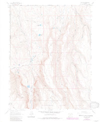
1963 Map of Lost Lake
USGS Topo · Published 1984About this map
Meaker Ranch and Miles Ranch sit along the northern reaches of this high-altitude landscape, where human settlement is defined by isolated homesteads and seasonal cabins within the Uncompahgre National Forest. Water management is central to the area's history, evidenced by the McKinley Ditch and several named reservoirs like Fitzpatrick Reservoir that redirected flows across the high plateaus. The topography is dominated by the massive Horse Mesa and High Mesa, which divide the complex drainage systems of the Little Cimarron River and the three branches of Blue Creek. For researchers, the presence of specific structures like the Sampson Cabin, Reynaldo Cabin, and Williams Cabin identifies exact sites of high-country activity. The network of trails, including the Butte Trail, suggests a landscape used for ranching and timber long before modern recreational access.
Find a feature on this map
37 named features on this map. Tap any name to fly to it.
Don’t see what you’re looking for? This feature index may not catch every label — zoom into the map to look around manually.
Map Details
Editions of this 1963 Lost Lake Map
4 editions found
Other maps of this area

1902 · Ouray
USGS Topo · 1:62,500

1903 · Lake City
USGS Topo · 1:62,500

1904 · Ouray
USGS Topo · 1:62,500

1905 · Lake City
USGS Topo · 1:62,500

1908 · Uncompahgre
USGS Topo · 1:125,000

1909 · Montrose
USGS Topo · 1:125,000

1911 · Uncompahgre
USGS Topo · 1:125,000

1911 · Montrose
USGS Topo · 1:125,000

1954 · Sapinero
USGS Topo · 1:24,000

1956 · Curecanti Needle
USGS Topo · 1:24,000