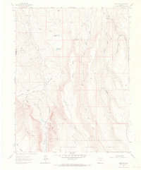
1963 Map of Lost Lake
USGS Topo · Published 1970About this map
Little Cimarron River and its high-elevation tributaries define this landscape within the Uncompahgre National Forest during the early 1960s. The area is characterized by isolated outposts and high-country water management, with Meaker Ranch and Miles Ranch marking the northern valley, while several remote dwellings like Sampson Cabin and Reynolds Cabin are tucked into the drainages of Blue Creek and its forks.
Find a feature on this map
35 named features on this map. Tap any name to fly to it.
Don’t see what you’re looking for? This feature index may not catch every label — zoom into the map to look around manually.
Map Details
Editions of this 1963 Lost Lake Map
4 editions found
Other maps of this area

1902 · Ouray
USGS Topo · 1:62,500

1903 · Lake City
USGS Topo · 1:62,500

1904 · Ouray
USGS Topo · 1:62,500

1905 · Lake City
USGS Topo · 1:62,500

1908 · Uncompahgre
USGS Topo · 1:125,000

1909 · Montrose
USGS Topo · 1:125,000

1911 · Uncompahgre
USGS Topo · 1:125,000

1911 · Montrose
USGS Topo · 1:125,000

1954 · Sapinero
USGS Topo · 1:24,000

1956 · Curecanti Needle
USGS Topo · 1:24,000