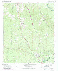
1962 Map of Louann
USGS Topo · Published 1986About this map
The Smackover Oil and Gas Field dominates the southern landscape of this 1962 survey, reflecting the intensive energy production that defined this portion of the Gulf Coastal Plain. Centered on the town of Louann, the map illustrates a complex network of drilling activity interspersed with agricultural settlements and river commerce. The Missouri Pacific railroad cuts a diagonal line through the territory, connecting smaller points like Elliott and Kirkland to larger regional markets.
Find a feature on this map
38 named features on this map. Tap any name to fly to it.
Don’t see what you’re looking for? This feature index may not catch every label — zoom into the map to look around manually.
Map Details
Editions of this 1962 Louann Map
3 editions found
Other maps of this area

1903 · Camden
USGS Topo · 1:125,000

1951 · Camden
USGS Topo · 1:24,000

1953 · El Dorado
USGS Topo · 1:250,000

1957 · El Dorado
USGS Topo · 1:250,000

1958 · El Dorado
USGS Topo · 1:250,000

1960 · El Dorado
USGS Topo · 1:250,000

1962 · Lisbon
USGS Topo · 1:24,000

1962 · Louann
USGS Topo · 1:24,000

1962 · Buena Vista
USGS Topo · 1:24,000

1962 · Smackover
USGS Topo · 1:24,000