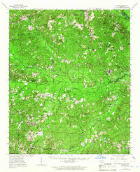
1964 Map of Louann
USGS Topo · Published 1966About this map
Louann and the surrounding pine-dominated timberlands of southern Arkansas are defined here by a mid-century energy landscape. Extensive petroleum operations, including the West Gum Creek Oil and Gas Field and Lisbon Oil and Gas Field, dominate the terrain, connected by a network of heavy-duty roads and a prominent Pipe Line. The rural social fabric is preserved through a high density of country churches and family burial grounds, such as Bethesda Cumberland Ch and the Patton Cem. Along the northeastern corner, the Ouachita River serves as a natural boundary, featuring historical access points like Frenchport Landing and White Hall Landing. This survey documents a period when small settlements like Buena Vista and Dumas City thrived alongside the Missouri Pacific railroad, reflecting the industrial and agricultural intersections of the region before the consolidation of these smaller communities.
Find a feature on this map
86 named features on this map. Tap any name to fly to it.
Don’t see what you’re looking for? This feature index may not catch every label — zoom into the map to look around manually.
Map Details
Editions of this 1964 Louann Map
2 editions found

Other maps of this area

1901 · Gurdon
USGS Topo · 1:125,000

1903 · Camden
USGS Topo · 1:125,000

1927 · El Dorado
USGS Topo · 1:62,500

1930 · El Dorado
USGS Topo · 1:62,500

1951 · Camden
USGS Topo · 1:24,000

1951 · El Dorado
USGS Topo · 1:62,500

1953 · El Dorado
USGS Topo · 1:250,000

1957 · El Dorado
USGS Topo · 1:250,000

1958 · El Dorado
USGS Topo · 1:250,000

1960 · El Dorado
USGS Topo · 1:250,000