
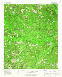
1964 Map of Louann
USGS Topo · Published 1964About this map
The Ouachita River winds through the northeast corner of this 1964 survey, marking the river-based commerce points of White Hall Landing and Frenchport Landing. The landscape is defined by the mid-century petroleum industry, with extensive drilling operations visible in the West Gum Creek Oil and Gas Field and the Bear Creek Oil and Gas Field. These industrial sites sit alongside established rural communities like Louann and Mt Holly.
Find a feature on this map
87 named features on this map. Tap any name to fly to it.
Don’t see what you’re looking for? This feature index may not catch every label — zoom into the map to look around manually.
Map Details
Editions of this 1964 Louann Map
2 editions found
Other maps of this area

1901 · Gurdon
USGS Topo · 1:125,000

1903 · Camden
USGS Topo · 1:125,000

1927 · El Dorado
USGS Topo · 1:62,500

1930 · El Dorado
USGS Topo · 1:62,500

1951 · Camden
USGS Topo · 1:24,000

1951 · El Dorado
USGS Topo · 1:62,500

1953 · El Dorado
USGS Topo · 1:250,000

1957 · El Dorado
USGS Topo · 1:250,000

1958 · El Dorado
USGS Topo · 1:250,000

1960 · El Dorado
USGS Topo · 1:250,000