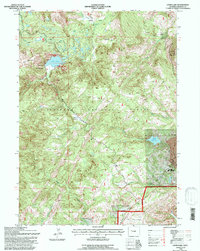
1991 Map of Louis Lake
USGS Topo · Published 1997About this map
Shoshone National Forest encompasses this high-elevation landscape, where the Louis Lake Resort serves as a focal point for activity along the shores of Louis Lake. The terrain is defined by dramatic shifts in topography, rising from Grannier Meadow and Maxon Basin toward the prominent heights of Limestone Mountain and Iron Mtn. This 1991 revision reflects a modern era of land management within the Lander Ranger District Boundary, showing a transition from industrial exploitation to recreation and conservation. Evidence of the region's mid-century industrial past is preserved in the location of the Columbia-Geneva Mines (U S Steel), while the water management systems including Rock Creek Reservoir and various segments labeled Ditch illustrate the ongoing human engineering of the high-country watershed.
Find a feature on this map
22 named features on this map. Tap any name to fly to it.
Don’t see what you’re looking for? This feature index may not catch every label — zoom into the map to look around manually.
Map Details
Editions of this 1991 Louis Lake Map
This is the sole edition of this map. No revisions or reprints were ever made.
Other maps of this area

1953 · Cony Mountain
USGS Topo · 1:24,000

1953 · Atlantic City
USGS Topo · 1:24,000

1953 · Fossil Hill
USGS Topo · 1:24,000

1953 · Louis Lake
USGS Topo · 1:24,000

1953 · South Pass City
USGS Topo · 1:24,000

1953 · Christina Lake
USGS Topo · 1:24,000

1954 · Wolf Point
USGS Topo · 1:24,000

1954 · Miners Delight
USGS Topo · 1:24,000

1955 · Lander
USGS Topo · 1:250,000

1958 · Lander
USGS Topo · 1:250,000