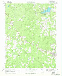
1970 Map of Louisa
USGS Topo · Published 1972About this map
Chesapeake And Ohio rails cut a direct path through this central Virginia landscape, connecting the town of Louisa with smaller trackside points like Trevilians and Mildred Crossing. The 1970 landscape is defined by its rural social infrastructure, with numerous small congregations such as Forest Hill Ch, Ebenezer Ch, and Bright Hope Ch serving as focal points for local communities. Near the northeastern corner, the developed resort character of Blue Ridge Shores around Lake Louisa contrasts with the surrounding agricultural and timbered terrain.
Find a feature on this map
44 named features on this map. Tap any name to fly to it.
Don’t see what you’re looking for? This feature index may not catch every label — zoom into the map to look around manually.
Map Details
Editions of this 1970 Louisa Map
4 editions found
Other maps of this area

1887 · Spottsylvania
USGS Topo · 1:125,000

1890 · Goochland
USGS Topo · 1:125,000

1891 · Palmyra
USGS Topo · 1:125,000

1892 · Spottsylvania
USGS Topo · 1:125,000

1892 · Goochland
USGS Topo · 1:125,000

1892 · Gordonsville
USGS Topo · 1:125,000

1895 · Palmyra
USGS Topo · 1:125,000

1897 · Palmyra
USGS Topo · 1:125,000

1942 · Mineral
USGS Topo · 1:31,680

1942 · Lahore
USGS Topo · 1:31,680