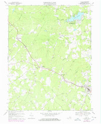
1970 Map of Louisa
USGS Topo · Published 1978About this map
Louisa and its surrounding countryside are captured during a period of transition in the late 1960s and 1970s. The Chesapeake and Ohio railroad corridor serves as the primary backbone for the region's movement, passing through historic communities like Trevilians and Green Springs. In the northeastern quadrant, the shoreline development of Blue Ridge Shores along Lake Louisa contrasts with the agricultural landscape of the south, where Byrd Mill Road follows Byrd Mill Creek. Genealogists will find a high density of rural landmarks, including several named churches such as Forest Hill Ch, Ebenezer Ch, and Weyland Ch. The presence of the G Depot Sch and a Drive-in Theater near Trevilians provides concrete evidence of the mid-century local social fabric before modern highway expansions altered these smaller crossroads.
Find a feature on this map
43 named features on this map. Tap any name to fly to it.
Don’t see what you’re looking for? This feature index may not catch every label — zoom into the map to look around manually.
Map Details
Editions of this 1970 Louisa Map
4 editions found
Other maps of this area

1887 · Spottsylvania
USGS Topo · 1:125,000

1890 · Goochland
USGS Topo · 1:125,000

1891 · Palmyra
USGS Topo · 1:125,000

1892 · Spottsylvania
USGS Topo · 1:125,000

1892 · Goochland
USGS Topo · 1:125,000

1892 · Gordonsville
USGS Topo · 1:125,000

1895 · Palmyra
USGS Topo · 1:125,000

1897 · Palmyra
USGS Topo · 1:125,000

1942 · Mineral
USGS Topo · 1:31,680

1942 · Lahore
USGS Topo · 1:31,680