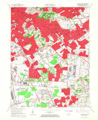
1965 Map of Louisville East
USGS Topo · Published 1967About this map
Cave Hill Cemetery and Calvary Cemetery anchor the historic Highlands district as mid-century development pushes eastward from central Louisville. This survey illustrates the rapid suburbanization of Jefferson County during the post-war era, with the newly established Henry Watterson Expressway (Interstate 264) carving through established neighborhoods like Audubon Park and Strathmoor Village. The landscape is a mix of traditional residential planning and large-scale industrial or institutional blocks, including the Kentucky Fair and Exposition Center and the dual aviation hubs of Bowman Field and Standiford Field. Numerous educational and religious institutions are plotted, from Bellarmine College to local parish schools like St Martha Sch, showing the dense community infrastructure of the 1960s. To the south, the terrain becomes more open around Okolona and Smyrna, where the Louisville and Nashville Railroad still defines the local transport corridor.
Find a feature on this map
155 named features on this map. Tap any name to fly to it.
Don’t see what you’re looking for? This feature index may not catch every label — zoom into the map to look around manually.
Map Details
Editions of this 1965 Louisville East Map
2 editions found
Other maps of this area

1905 · Prospect
USGS Topo · 1:62,500

1907 · Louisville
USGS Topo · 1:62,500

1909 · Kosmosdale
USGS Topo · 1:48,000

1912 · Prospect
USGS Topo · 1:62,500

1912 · Kosmosdale
USGS Topo · 1:62,500

1937 · Jeffersonville
USGS Topo · 1:24,000

1939 · New Albany
USGS Topo · 1:24,000

1946 · Jeffersonville
USGS Topo · 1:24,000

1946 · New Albany
USGS Topo · 1:24,000
1950 · New Albany
USGS Topo · 1:24,000