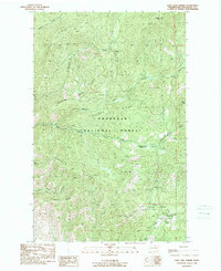
1989 Map of Loup Loup Summit
USGS Topo · Published 1989About this map
Okanogan National Forest dominates this landscape in north-central Washington, where high-altitude ridges and creek drainage systems converge. The area is anchored by the Loup Loup Summit, a notable passage that serves as the focal point for regional recreation during the late 1980s. Activity is concentrated in the southeast, featuring the Loup Loup Recreation Area with its Ski Lift, while several camps such as Loup Loup Campground and the JR Campground suggest a well-established seasonal use of the forest. The map detail highlights the complex network of waterways, including Beaver Creek and its various tributaries like the Middle Fork and South Fork. Significant terrain features such as Bobcat Mtn, Bear Mtn, and the expansive Beaver Ridge define the vertical relief, while South Fork Meadows offers a break in the timbered slopes. Trace signs of industry appear through scattered Gravel Pits alongside forest roads.
Find a feature on this map
28 named features on this map. Tap any name to fly to it.
Don’t see what you’re looking for? This feature index may not catch every label — zoom into the map to look around manually.
Map Details
Editions of this 1989 Loup Loup Summit Map
This is the sole edition of this map. No revisions or reprints were ever made.
Other maps of this area

1899 · Methow
USGS Topo · 1:125,000

1901 · Methow
USGS Topo · 1:125,000

1905 · Okanogan
USGS Topo · 1:125,000

1906 · Chopaka
USGS Topo · 1:125,000

1954 · Okanogan
USGS Topo · 1:250,000

1955 · Concrete
USGS Topo · 1:250,000

1956 · Loup Loup
USGS Topo · 1:62,500

1956 · Tiffany Mountain
USGS Topo · 1:62,500

1958 · Concrete
USGS Topo · 1:250,000

1958 · Okanogan
USGS Topo · 1:250,000