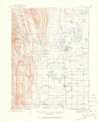
1906 Map of Loveland
USGS Topo · Published 1965About this map
The agrarian and industrial roots of the northern Front Range are visible in this survey of Loveland and its surrounding agricultural plains. The landscape is defined by an intricate network of irrigation ditches and reservoirs, including Lake Loveland, Fossil Creek Reservoir, and the Boyd Lakes complex, which supported the region's burgeoning sugar beet and farming economy. In the foothills to the west, the Roosevelt National Forest boundary meets prominent terrain like Flatiron Mtn and Green Ridge, while the Big Thompson River cuts through the canyon toward the valley floor.
Find a feature on this map
86 named features on this map. Tap any name to fly to it.
Don’t see what you’re looking for? This feature index may not catch every label — zoom into the map to look around manually.
Map Details
Editions of this 1906 Loveland Map
5 editions found
Other maps of this area

1902 · Greeley
USGS Topo · 1:125,000

1902 · Boulder
USGS Topo · 1:62,500

1904 · Niwot
USGS Topo · 1:62,500

1904 · Boulder
USGS Topo · 1:62,500

1905 · Mount Olympus
USGS Topo · 1:62,500

1906 · Loveland
USGS Topo · 1:62,500

1906 · Fort Collins
USGS Topo · 1:62,500

1907 · Mount Olympus
USGS Topo · 1:62,500

1907 · Livermore
USGS Topo · 1:125,000

1908 · Loveland
USGS Topo · 1:62,500