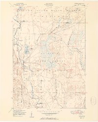
1951 Map of Lovells
USGS Topo · Published 1951About this map
The North Branch Au Sable River defines this northern Michigan landscape, carving a path through the Au Sable State Forest and into the Camp Grayling Military Reservation. The small settlement of Lovells serves as a focal point for the region, housing the Lovells Town Hall, the Community Chapel, and the Lovells Cemetery. This era reveals the area's dual identity as both a strategic military training ground and a premier recreational destination, evidenced by the presence of an Emergency airfield alongside established sporting landmarks like the Au Sable Trout & Gun Club and High Bank Lodge. The rugged nature of the terrain is further emphasized by the network of unpaved routes like the Bald Hill Truck Trail and the clustered seasonal dwellings at Johns Cabins near Shupac Lake.
Find a feature on this map
27 named features on this map. Tap any name to fly to it.
Don’t see what you’re looking for? This feature index may not catch every label — zoom into the map to look around manually.
Map Details
Editions of this 1951 Lovells Map
2 editions found

Other maps of this area

1949 · Lewiston
USGS Topo · 1:62,500

1949 · Otsego Lake
USGS Topo · 1:62,500

1949 · Grayling
USGS Topo · 1:62,500

1950 · Lewiston
USGS Topo · 1:24,000

1950 · Comstock Hills
USGS Topo · 1:24,000

1950 · Johannesburg
USGS Topo · 1:24,000

1950 · Lovells
USGS Topo · 1:24,000

1950 · Turtle Lake
USGS Topo · 1:24,000

1951 · K P Lake
USGS Topo · 1:24,000

1951 · Comstock Hills
USGS Topo · 1:24,000
Featured Places
- Lovells, MI
- Chester Township, MI
- Lovells Township, MI
- Grayling Charter Township, MI
- Charlton Township, MI