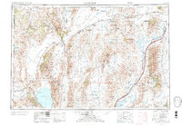
1955 Map of Lovelock
USGS Topo · Published 1973About this map
The Humboldt River corridor anchors this mid-century look at the High Desert, tracing the critical water and rail routes that sustained the Great Basin's interior. Centered on the town of Lovelock, the landscape reveals a complex network of seasonal sinks and permanent water bodies, from the vast Pyramid Lake within the Pyramid Lake Indian Reservation to the terminal drainage of the Humboldt Sink. This 1955 survey captures the regional reliance on the Southern Pacific and Western Pacific railroads, which connected isolated sidings like Pronto and Reynard Siding across the arid basins.
Find a feature on this map
99 named features on this map. Tap any name to fly to it.
Don’t see what you’re looking for? This feature index may not catch every label — zoom into the map to look around manually.
Map Details
Editions of this 1955 Lovelock Map
5 editions found

Other maps of this area

1882 · Paradise
USGS Topo · 1:250,000

1886 · Alturas
USGS Topo · 1:250,000

1886 · Honey Lake
USGS Topo · 1:250,000

1886 · Disaster
USGS Topo · 1:250,000

1886 · Granite Range
USGS Topo · 1:250,000

1889 · Long Valley
USGS Topo · 1:250,000

1890 · Wadsworth
USGS Topo · 1:125,000

1890 · Sierraville
USGS Topo · 1:125,000

1891 · Honey Lake
USGS Topo · 1:250,000

1891 · Reno
USGS Topo · 1:125,000