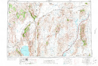
1955 Map of Lovelock
USGS Topo · Published 1973About this map
Lovelock serves as the primary hub of this high-desert landscape, situated where the Humboldt River terminates in the expansive Humboldt Lake Sink and the nearby Carson Sink. The region's mid-century economic structure is defined by the parallel paths of the Western Pacific and Southern Pacific railroads, which support a network of remote outposts such as Gerlach, Empire, and Imlay. Water management is central to the area's geography, visible through the significant Rye Patch Reservoir and the Pitt-Taylor Reservoirs along the river's course.
Find a feature on this map
147 named features on this map. Tap any name to fly to it.
Don’t see what you’re looking for? This feature index may not catch every label — zoom into the map to look around manually.
Map Details
Editions of this 1955 Lovelock Map
5 editions found

Other maps of this area

1882 · Paradise
USGS Topo · 1:250,000

1886 · Alturas
USGS Topo · 1:250,000

1886 · Honey Lake
USGS Topo · 1:250,000

1886 · Disaster
USGS Topo · 1:250,000

1886 · Granite Range
USGS Topo · 1:250,000

1889 · Long Valley
USGS Topo · 1:250,000

1890 · Wadsworth
USGS Topo · 1:125,000

1890 · Sierraville
USGS Topo · 1:125,000

1891 · Honey Lake
USGS Topo · 1:250,000

1891 · Reno
USGS Topo · 1:125,000