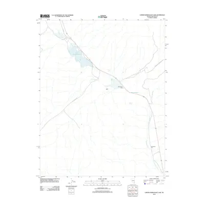
2012 Map of Lower Pahranagat Lake
USGS Topo · Published 2012About this map
Lower Pahranagat Lake and its surrounding wetlands form a vital riparian corridor through the Pahranagat Valley, as documented in this 2012 survey. This arid landscape is defined by the life-sustaining waters of Big Spring, Lone Tree Spring, and Evergreen Spring, which support local agricultural activity at sites like the Gould Ranch. The map traces the natural drainage of the Pahranagat Wash as it moves south through Evergreen Flat, paralleling modern infrastructure and the remnants of earlier routes like Old Corn Creek Rd and Old Hwy 93. This topographic study provides a clear view of how water resources and historical transportation paths have shaped the habitation patterns of Lincoln County, Nevada, from the shores of Middle Pond to the southern reaches of Maynard Lake.
Find a feature on this map
14 named features on this map. Tap any name to fly to it.
Don’t see what you’re looking for? This feature index may not catch every label — zoom into the map to look around manually.
Map Details
Editions of this 2012 Lower Pahranagat Lake Map
This is the sole edition of this map. No revisions or reprints were ever made.
Other maps of this area

1885 · Pioche
USGS Topo · 1:250,000

1886 · Pioche
USGS Topo · 1:250,000

1945 · Alamo
USGS Topo · 1:125,000

1954 · Caliente
USGS Topo · 1:250,000

1959 · Caliente
USGS Topo · 1:250,000

1969 · Alamo SE
USGS Topo · 1:24,000
1969 · Delamar 3 SW
USGS Topo · 1:24,000
1969 · Lower Pahranagat Lake SE
USGS Topo · 1:24,000

1969 · Lower Pahranagat Lake
USGS Topo · 1:24,000
1969 · Lower Pahranagat Lake SW
USGS Topo · 1:24,000