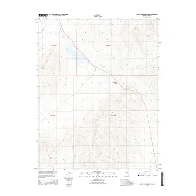
2015 Map of Lower Pahranagat Lake
USGS Topo · Published 2015About this map
Lower Pahranagat Lake and its surrounding wetlands form a vital riparian corridor through this arid stretch of Lincoln County. The 2015 landscape is defined by the hydrologic connection between Middle Pond, the primary lake, and Maynard Lake to the south, all situated within the broader Pahranagat Valley. This water system is supported by numerous named water sources, including Hout Spring, Lone Tree Spring, and Big Spring, which provide critical habitat between the rising elevations of the East Pahranagat Range and the Sheep Range. Human activity is marked by the historical alignment of Old US 93 Rd and the more remote Refuge Rd and Turtle Walk Rd. The map illustrates the concentration of life near the water's edge, contrasting sharply with the dry expanse of Evergreen Flat and the intermittent course of the Pahranagat Wash.
Find a feature on this map
19 named features on this map. Tap any name to fly to it.
Don’t see what you’re looking for? This feature index may not catch every label — zoom into the map to look around manually.
Map Details
Editions of this 2015 Lower Pahranagat Lake Map
This is the sole edition of this map. No revisions or reprints were ever made.
Other maps of this area

1885 · Pioche
USGS Topo · 1:250,000

1886 · Pioche
USGS Topo · 1:250,000

1945 · Alamo
USGS Topo · 1:125,000

1954 · Caliente
USGS Topo · 1:250,000

1959 · Caliente
USGS Topo · 1:250,000

1969 · Alamo SE
USGS Topo · 1:24,000
1969 · Delamar 3 SW
USGS Topo · 1:24,000
1969 · Lower Pahranagat Lake SE
USGS Topo · 1:24,000

1969 · Lower Pahranagat Lake
USGS Topo · 1:24,000
1969 · Lower Pahranagat Lake SW
USGS Topo · 1:24,000