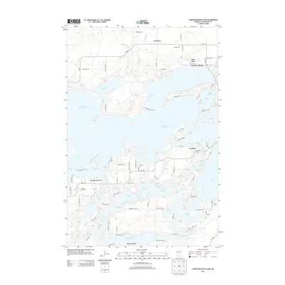
2013 Map of Lower Whitefish Lake
USGS Topo · Published 2013About this map
Lower Whitefish Lake and its interconnected northern Minnesota waters dominate this Crow Wing County landscape, showcasing a complex aquatic geography defined by narrow channels and expansive basins. Small communities like Manhattan Beach and Fifty Lakes occupy the higher ground between these water bodies, while Breezy Point and Crosslake serve as focal points for the region's long-established recreational character. The map illustrates how local transit has adapted to the terrain, with routes like Co Hwy-1 and Co Hwy-66 skirting the edges of Big Trout Lake and Arrowhead Lake. Land use patterns are further highlighted by the Whitefish Golf Course and Highview Campground, reflecting the area's transition from early settlements like Swanburg to its modern identity as a premier lake destination. Genealogists and local historians can trace legacy sites such as the Swanburg Cem and the small residential clusters at Lakewood Court and Ideal Corners.
Find a feature on this map
96 named features on this map. Tap any name to fly to it.
Don’t see what you’re looking for? This feature index may not catch every label — zoom into the map to look around manually.
Map Details
Editions of this 2013 Lower Whitefish Lake Map
This is the sole edition of this map. No revisions or reprints were ever made.
Other maps of this area

1953 · Brainerd
USGS Topo · 1:250,000

1957 · Brainerd
USGS Topo · 1:250,000

1958 · Brainerd
USGS Topo · 1:250,000

1959 · Trommald
USGS Topo · 1:24,000

1959 · Pelican Lake
USGS Topo · 1:24,000

1959 · Nisswa
USGS Topo · 1:24,000

1959 · Lower Whitefish Lake
USGS Topo · 1:24,000

1959 · Jenkins
USGS Topo · 1:24,000

1960 · Cross Lake
USGS Topo · 1:24,000

1965 · Brainerd
USGS Topo · 1:250,000