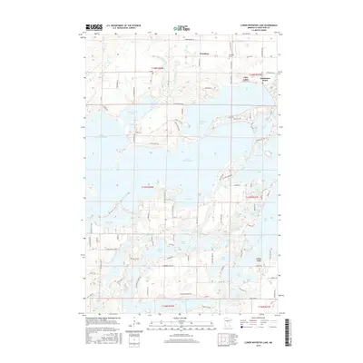
2016 Map of Lower Whitefish Lake
USGS Topo · Published 2016About this map
Lower Whitefish Lake and its intricate network of interconnected waterways dominate this Crow Wing County landscape. The mid-2010s shoreline is densely developed with access roads like Whitefish Ave and Long Beach Rd serving the many peninsulas and bays. To the north, the small community of Fifty Lakes sits near Manhattan Beach, while the settlement of Swanburg is marked by the Swanburg Cem along Old Grade Rd. The complex hydrology of the region is evident in the transition from larger bodies like Upper Whitefish Lake and Big Trout Lake to smaller, distinct basins such as Pecks Puddle, Hooligans Hole, and Little Star Lake. This survey illustrates a modern recreation-focused landscape where the original township grids of t137n r28w and surrounding ranges have been largely reshaped by lakeside residential expansion and intricate forest road networks.
Find a feature on this map
114 named features on this map. Tap any name to fly to it.
Don’t see what you’re looking for? This feature index may not catch every label — zoom into the map to look around manually.
Map Details
Editions of this 2016 Lower Whitefish Lake Map
This is the sole edition of this map. No revisions or reprints were ever made.
Other maps of this area

1953 · Brainerd
USGS Topo · 1:250,000

1957 · Brainerd
USGS Topo · 1:250,000

1958 · Brainerd
USGS Topo · 1:250,000

1959 · Trommald
USGS Topo · 1:24,000

1959 · Pelican Lake
USGS Topo · 1:24,000

1959 · Nisswa
USGS Topo · 1:24,000

1959 · Lower Whitefish Lake
USGS Topo · 1:24,000

1959 · Jenkins
USGS Topo · 1:24,000

1960 · Cross Lake
USGS Topo · 1:24,000

1965 · Brainerd
USGS Topo · 1:250,000