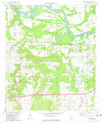
1981 Map of Lowndesboro
USGS Topo · Published 1981About this map
Lowndesboro anchors this southern Alabama landscape, situated just south of the winding Alabama River and the expansive Jones Bluff Lake. The map reveals a community defined by its deep roots, evidenced by an exceptionally high density of family and church burial grounds such as Alexander Cem, Oakview Cem, and the Yankee Town Cem. Educational and spiritual life is centered around Lowndes Academy and numerous rural congregations including Mt Canaan Ch and St Pauls Ch.
Find a feature on this map
54 named features on this map. Tap any name to fly to it.
Don’t see what you’re looking for? This feature index may not catch every label — zoom into the map to look around manually.
Map Details
Editions of this 1981 Lowndesboro Map
2 editions found
Other maps of this area

1927 · Montgomery
USGS Topo · 1:48,000

1930 · Montgomery
USGS Topo · 1:62,500

1953 · Montgomery
USGS Topo · 1:250,000

1956 · Montgomery
USGS Topo · 1:250,000

1957 · Montgomery
USGS Topo · 1:250,000

1957 · Letohatchee
USGS Topo · 1:62,500

1957 · Autaugaville
USGS Topo · 1:62,500

1958 · Montgomery
USGS Topo · 1:62,500

1975 · Autaugaville SW
USGS Topo · 1:24,000

1975 · Autaugaville SE
USGS Topo · 1:24,000