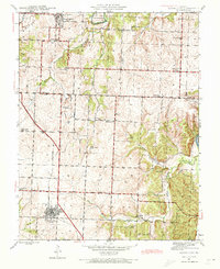
1941 Map of Lowry City
USGS Topo · Published 1973About this map
Lowry City and Brownington anchor this early 1940s landscape, illustrating a rural Missouri economy centered on rail transport and education. The St Louis San Francisco railroad cuts a diagonal path through the terrain, connecting small settlements like Chloe to the larger regional network. This era shows a remarkably dense system of rural education, with nearly a dozen schools such as Diamond Point Sch, County Line Sch, and Hay Creek Sch serving scattered farmstead families. The presence of a Mine Dump near the northern boundary indicates localized extraction, while the South Grand River and Big Muddy Creek drainage systems define the area's topography. Genealogists will find significant value in the distribution of family-connected sites, including Park Grove Cem and Landecker Ch, which served as the social fabric for the surrounding agricultural community before the consolidation of these small rural districts.
Find a feature on this map
29 named features on this map. Tap any name to fly to it.
Don’t see what you’re looking for? This feature index may not catch every label — zoom into the map to look around manually.
Map Details
Editions of this 1941 Lowry City Map
3 editions found
Other maps of this area

1887 · Clinton
USGS Topo · 1:125,000

1894 · Clinton
USGS Topo · 1:125,000

1938 · Monegaw Springs
USGS Topo · 1:24,000

1939 · Osceola
USGS Topo · 1:24,000

1940 · Osceola
USGS Topo · 1:24,000
1940 · Monegaw Springs
USGS Topo · 1:24,000

1940 · Iconium
USGS Topo · 1:24,000

1941 · Valhalla
USGS Topo · 1:24,000

1941 · Lowry City
USGS Topo · 1:24,000
1944 · Iconium
USGS Topo · 1:24,000