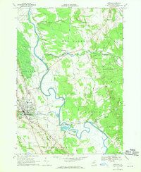
1966 Map of Lowville
USGS Topo · Published 1970About this map
The Black River and its winding oxbows dominate the Lewis County landscape, defining the boundaries between the town centers of Lowville and Watson. In the mid-1960s, this area served as a regional hub for government and education, evidenced by the Central Sch, County Voc Sch, and the County Fairgrounds. The village of Lowville shows a dense grid of streets near the Penn Central railroad line, while the surrounding countryside is characterized by agricultural roads and rural institutions like St Peters Ch. To the east, the terrain shifts into the State Forest Preserve, where the landscape becomes more wooded and less populated. Water management and local industry are visible through the presence of an Aqueduct, several Gravel Pits, and a Pumping Sta near the riverbank. Significant family and historical markers include Beaches Bridge Cem and Ebblie Cem, which offer critical data points for genealogical research in this Black River Valley community.
Find a feature on this map
62 named features on this map. Tap any name to fly to it.
Don’t see what you’re looking for? This feature index may not catch every label — zoom into the map to look around manually.
Map Details
Editions of this 1966 Lowville Map
2 editions found
Other maps of this area

1902 · Carthage
USGS Topo · 1:62,500

1904 · Carthage
USGS Topo · 1:62,500

1905 · Port Leyden
USGS Topo · 1:62,500

1906 · Highmarket
USGS Topo · 1:62,500

1907 · Port Leyden
USGS Topo · 1:62,500

1911 · Lowville
USGS Topo · 1:62,500

1913 · Lowville
USGS Topo · 1:62,500

1940 · Port Leyden
USGS Topo · 1:62,500

1943 · West Lowville
USGS Topo · 1:31,680

1943 · Carthage
USGS Topo · 1:31,680