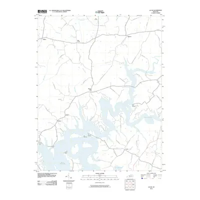
2010 Map of Lucas
USGS Topo · Published 2010About this map
Barren River Lake dominates this portion of Barren County, its branching shoreline creating a complex geography of peninsulas and landings. The massive Barren River Dam near Finney anchors the southwestern corner, while the narrow channel at The Narrows serves as a central bottleneck for the reservoir. Small unincorporated communities like Lucas, Beckton, and Rocky Hill sit on the higher ground surrounding the water, connected by a network of winding roads named for local families and early landmarks, such as Steam Mill Rd and Powell Cemetery Rd.
Find a feature on this map
56 named features on this map. Tap any name to fly to it.
Don’t see what you’re looking for? This feature index may not catch every label — zoom into the map to look around manually.
Map Details
Editions of this 2010 Lucas Map
This is the sole edition of this map. No revisions or reprints were ever made.
Other maps of this area

1922 · Mammoth Cave
USGS Topo · 1:62,500

1923 · Mammoth Cave
USGS Topo · 1:62,500

1926 · Scottsville
USGS Topo · 1:62,500

1935 · Horse Cave
USGS Topo · 1:48,000

1938 · Horse Cave
USGS Topo · 1:62,500

1953 · Tracy
USGS Topo · 1:24,000

1953 · Glasgow South
USGS Topo · 1:24,000

1954 · Evansville
USGS Topo · 1:250,000

1954 · Austin
USGS Topo · 1:24,000
1954 · Park City
USGS Topo · 1:24,000