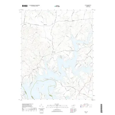
2019 Map of Lucas
USGS Topo · Published 2019About this map
Barren River Lake dominates the southern landscape of this Barren County region, where the intricate shoreline of the reservoir reaches into numerous valleys and hollows. The prominent landform known as The Narrows creates a narrow land bridge between large fingers of the lake, connecting the community of Finney to the western shore. The geography is defined by the transition from upland ridges like Burton Ridge to the inundated creek beds of Skaggs Creek and Cooks Creek. Small settlements and agricultural hubs such as Lucas, Rocky Hill, and Red Cross are scattered across the northern half of the map, linked by a dense network of country roads like Old Bowling Green Road. Genealogists may find interest in the documented locations of the Henderson Cemetery and Allen Cemetery, which remain as markers of the area's rural heritage amidst the modern recreational landscape of the lake.
Find a feature on this map
96 named features on this map. Tap any name to fly to it.
Don’t see what you’re looking for? This feature index may not catch every label — zoom into the map to look around manually.
Map Details
Editions of this 2019 Lucas Map
This is the sole edition of this map. No revisions or reprints were ever made.
Other maps of this area

1922 · Mammoth Cave
USGS Topo · 1:62,500

1923 · Mammoth Cave
USGS Topo · 1:62,500

1926 · Scottsville
USGS Topo · 1:62,500

1935 · Horse Cave
USGS Topo · 1:48,000

1938 · Horse Cave
USGS Topo · 1:62,500

1953 · Tracy
USGS Topo · 1:24,000

1953 · Glasgow South
USGS Topo · 1:24,000

1954 · Evansville
USGS Topo · 1:250,000

1954 · Austin
USGS Topo · 1:24,000
1954 · Park City
USGS Topo · 1:24,000