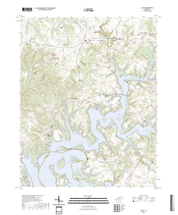
2022 Map of Lucas
USGS Topo · Published 2022About this map
The Barren River Lake reservoir dominates the landscape of this southern Kentucky quadrangle, where the waters of the Barren River and Skaggs Creek converge at the county line. The topography is defined by the winding shoreline and prominent features like The Narrows, which separate different arms of the lake. Historically, this area is characterized by numerous small rural settlements and an exceptionally high density of family cemeteries. Localities such as Rocky Hill, Beckton, and Finney serve as hubs for a network of country roads including the Old Bowling Green Rd. The presence of several distinct church-affiliated burying grounds, including the Old Zion Methodist Church Cem and Rocky Hill Baptist Church Cem, alongside the Reinterment Cem Number 1, reflects the community's genealogical roots and the landscape changes necessitated by the creation of the reservoir.
Find a feature on this map
125 named features on this map. Tap any name to fly to it.
Don’t see what you’re looking for? This feature index may not catch every label — zoom into the map to look around manually.
Map Details
Editions of this 2022 Lucas Map
This is the sole edition of this map. No revisions or reprints were ever made.
Other maps of this area

1922 · Mammoth Cave
USGS Topo · 1:62,500

1923 · Mammoth Cave
USGS Topo · 1:62,500

1926 · Scottsville
USGS Topo · 1:62,500

1935 · Horse Cave
USGS Topo · 1:48,000

1938 · Horse Cave
USGS Topo · 1:62,500

1953 · Tracy
USGS Topo · 1:24,000

1953 · Glasgow South
USGS Topo · 1:24,000

1954 · Evansville
USGS Topo · 1:250,000

1954 · Austin
USGS Topo · 1:24,000
1954 · Park City
USGS Topo · 1:24,000